| Main Page | The Route | The People | Dispatches | Resources |
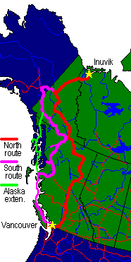


Here is the detailed itinerary. As it currently stands, the trip leaves 3 days 'unassigned' so that breakdowns won't stress out the travellers. If you have any questions about this adventure, drop a letter to Ron Lussier (coyote@vanagon.com).
Note that there are two extensions added to the end of this itinerary. The first is from the San Jose, California area to Vancouver via Roslyn, Washington. The second is a Alaskan Marine Highway trip from Haines, Alaska to Prince Rupert, B.C. via Petersburg and Ketchikan, Alaska.
Both of these extensions are optional. Many folks will be taking the land route for the entire trip.
Key:
- Paved travel
- Unpaved travel
- Options for campgrounds
| Northbound route from Vancouver | |||
| Trip day & Date | Segment | Km | Miles |
|---|---|---|---|
| (-2) Sat 7/20 | Early birds arrive in Vancouver. Parking and sleeping arrangements at Tobin's place (West End). | ||
| (-1) Sun 7/21 | Sightseeing in Vancouver, last-minute gathering of provisions. Entire contingent arrives in Vancouver by today. Group dinner at the Tomato Cafe, Cambie at 17th. Parking at Tobin's place in West End (Space for 6 or 7 folks inside, others may street camp.) | ||
| Trip begins! | |||
| (1) Mon 7/22 |
| 685 | 425 |
| Camping | Free camping in the Quesnel area (unserviced.) | ||
| (2) Tue 7/23 |
| 343 | 213 |
| Camping | Free camping in the Chetwynd area (unserviced.) | ||
| (3) Wed 7/24 |
| 620 | 385 |
| Camping |
| ||
| (4) Thu 7/25 |
| 310 | 193 |
| Camping |
| ||
| (5) Fri 7/26 |
| 458 | 285 |
| Camping |
| ||
| (6) Sat 7/27 |
| 475 | 295 |
| Camping |
| ||
| (7) Sun 7/28 |
| 400 | 250 |
| Camping |
| ||
| (8) Mon 7/29 |
NOTE: If mechanical repairs or parts are needed we may move the Dawson City day to today instead of saving it for Aug 3 on our return from the Dempster. | 391 | 243 |
| Camping |
| ||
| (9) Tue 7/30 Inuvik! |
| 365 | 227 |
| Camping |
| ||
| (10) Wed 7/31 | Inuvik, and optional day-trip by air to Tuktoyuktuk on the Beaufort Sea (Cost: $95.00 pp return in 1995) | ---- | ---- |
| Camping |
| ||
| Southbound route | |||
| Trip day & Date | Segment | Km | Miles |
|---|---|---|---|
| (11) Thu 8/1 |
| 365 | 227 |
| Camping |
| ||
| (12) Fri 8/2 |
| 391 | 243 |
| Camping |
| ||
| (13) Sat 8/3 | Exploration, provisioning, and vehicle maintenance in Dawson City. | ---- | ---- |
| Camping |
| ||
| (14) Sun 8/4 |
| 202 | 125 |
| Camping |
| ||
| (15) Mon 8/5 |
| 567 | 352 |
| Camping |
| ||
| (16) Tue 8/6 |
>>> People taking the Alaska Marine Highway south to Prince Rupert will
break off here and head S to Haines, AK to catch the ferry today.
The group may re-join at Prince Rupert, B.C.
>>> Christa, Tobin and others not taking the Alaska Marine Highway system will proceed E on Alaska Highway to Whitehorse. Exploration, provisioning, and vehicle maintenance in Whitehorse. In evening, proceed to campsite. | 160 | 100 |
| Camping |
| ||
| (17) Wed 8/7 |
| 550 | 342 |
| Camping |
| ||
| (18) Thu 8/8 |
| 454 | 282 |
| Camping |
(We may camp in vicinity of Dease Lake if the Telegraph Creek Road proves to be very slow going.) | ||
| (19) Fri 8/9 |
| 340 | 211 |
| Camping | Free camping near Stewart, B.C. | ||
| (20) Sat 8/10 |
| 450 | 280 |
| Camping | Camping east of Prince Rupert. | ||
| (21) Sun 8/11 |
Exploration in Prince Rupert
>>> This also functions as a break-down allowance day. >>> The folks who came down on the Alaska Marine Highway may meet back up with us here, or they may have already landed at Prince Rupert. >>> Group may split up here again: Those driving overland back to Vancouver leave today towards Prince George; those taking B.C. Ferries will leave Monday morning for Port Hardy. The two groups should arrive back in Vancouver again at about the same time. | ---- | ---- |
| Camping | |||
| (22) Mon 8/12 |
B.C.
Ferry "Queen of the North" to Port Hardy Departs Prince Rupert 7:30 am, arrives Port Hardy 10:30 pm same day. All propane must be shut off and tagged closed. COSTS: (in CDN $)
Vehicle 6'8" or under: $206.00
Overheight vehicle: $344.00
Driver or passenger: $100.00 each
Children: $ 50.00 each
Day rooms (optional): $ 43.00
Our 1976 Westfalia is exactly 6'8", so we will not be charged overheight if we remove everything from the roof rack. We will be paying $406.00 Canadian (roughly $292.00 US) not including a room. It is strongly suggested that people interested in taking this route with B.C. Ferries reserve space for themselves and their vehicle as soon as possible. This is an extremely popular route in the summer. | ---- | ---- |
| Camping |
| ||
| (23) Tue 8/13 |
        COSTS:  (all costs are U.S.$)
        Vehicle 7'0" or under: $27.00
        Overheight vehicle:    $49.00
        Driver or passenger:   $ 6.50 each
| 410 | 255 |
| Camping |
| ||
Extension: Northbound route from San Jose via Roslyn, WA
| Trip day & Date | Segment | Km | Miles |
|---|---|---|---|
| (-5) 7/17 |
| ? | ? |
| Camping |
| ||
| (-4) 7/18 |
| 605 | 376 |
| Camping |
| ||
| (-3) 7/19 |
| 404 | 251 |
| Camping |
| ||
| (-2) 7/20 |
| 444 | 276 |
| Trip day & Date | Segment | Km | Miles |
|---|---|---|---|
| (15) Mon 8/5 |
| 254 | 158 |
| Camping |
| ||
| (16) Tue 8/6 |
Take the Alaska
Ferry
"Columbia" to Petersburg, via Sitka.
Departs Haines 10:00am, arrives Sitka 1:30am on Wednesday. Leaves Sitka
at 3:30am on Wednesday, and arrives at Petersburg at 3:15pm on Wednesday.
    COSTS:  (all costs are U.S.$)
    Vehicle up to 15':     $129.00
    Driver or passenger:   $ 58.00 each
    Children (2-11 years): $ 30.00 each
    Cabins (optional):     $ 62.00 2-berth
                           $ 97.00 4-berth
| ---- | ---- |
| Camping |
| ||
| (17) Wed 8/7 | Arrive in Petersburg in the afternoon. Petersburg is a Norwegian fishing community. | ||
| Camping |
| ||
| (18) Thu 8/8 | Spend the day in Petersburg. Perhaps go hiking. | ||
| Camping |
| ||
| (19) Fri 8/9 |
Take the Alaska
Ferry
"Malaspina" to Ketchikan.
Departs Petersburg 7:00am, arrives Ketchikan at 8:30pm.
    COSTS:  (all costs are U.S.$)
    Vehicle up to 15':     $ 80.00
    Driver or passenger:   $ 38.00 each
    Children (2-11 years): $ 20.00 each
| ---- | ---- |
| Camping |
| ||
| (20) Sat 8/10 | Hang out in Ketchikan for the day. | ---- | ---- |
| Camping |
| ||
| (21) Sun 8/11 | Hang out in Ketchikan for the day. | ---- | ---- |
| Camping |
| ||
| (22) Mon 8/12 |
Take the Alaska
Ferry
"Malaspina" from Ketchikan to Prince Rupert.
Departs Ketchikan 2:15 am, arrives Prince Rupert 9:15am.
    COSTS:  (all costs are U.S.$)
    Vehicle up to 15':     $ 75.00
    Driver or passenger:   $ 38.00 each
    Children (2-11 years): $ 180 each
    Cabins (optional):     $ 43.00 2-berth
                           $ 63.00 4-berth
| ---- | ---- |
| Camping |
| ||
| (22) Mon 8/12 | Arrive in Prince Rupert 9:15 am. Start driving south towards Vancouver, rejoining everyone there. |
Tobin writes:
I've tried to plan the trip based on a 4-week holiday, and have tried to keep the driving time/day down to sane levels, and have planned in a few non-driving days to allow for relaxation, repairs, etc. I think we can learn an important lesson from the Schwarzemeister's GNATT experience: too much driving in too little time can make a tour more wearing than necessary.The main staging area for the trip will be my place in Vancouver, B.C. Vancouver is located about 2 1/2 hours north of Seattle, WA, so is easily accessible by interstate highway from anywhere in the US. Canadians may want to join up with the tour in Vancouver, in Prince George, B.C., or in Watson Lake, Yukon Territory, depending on your location and time frame.
Vancouver is one day's drive from Missoula, MT, and the California border, and is 20 hours driving time from the Bay Area. Realistically, Vancouver is a little over two days from San Diego, and almost 4 days from Chicago on interstate highways.
Once we leave Vancouver, the pace will be slower, and we will have time to enjoy the sights and smell the flowers. I think we should plan to stay in (free!) Forest Service campsites wherever possible. These sites are typically located on alpine lakes, next to waterfalls, or next to rivers or alpine streams. They are often several miles off the main road, accessible by dirt logging road. Off-road vehicle modifications should not be necessary, although anyone with a front air dam may want to remove it before starting the trip.
While we should plan to be as self-sufficient as possible (including shower/bathing equipment), we will stop every few days somewhere where Martha can have a hot shower. :)
Most of the route is paved, and apparently even fairly large RVs are making the trip to Inuvik these days, so this is not Baja off-road type stuff.
This is some of the most beautiful, desolate, and remote country you could ever expect to drive to. There will be about 18 - 19 hours of daylight per day, and temperatures will likely be between 55 and 75 degrees F in Inuvik, and may be substantially warmer in Northern B.C and the Southern Yukon. August is typically a dry month in the Far North. Bugs will be a problem, but will not be neary as bad as in late May - July. I would hope we could take the short bush plane flight from Inuvik to Tuktoyaktuk on the Beaufort Sea for day trip. Cost for the one day flight to Tuk is $95.00 CDN per person.
coyote@vanagon.com
Copyright © 1997-1999, Ron Lussier. All rights reserved.